Chris Yesson
Research Fellow
IoZ scientists Chris Yesson and Emmeline Broad share their experiences as they investigate the deep-sea floor in Greenland. Updates will be added to this blog throughout their trip.
Chris and Emme recently shared LIVE video footage with viewers on Facebook. Watch the recording of the live-stream and see what they found!
A warm return to Reykjavik
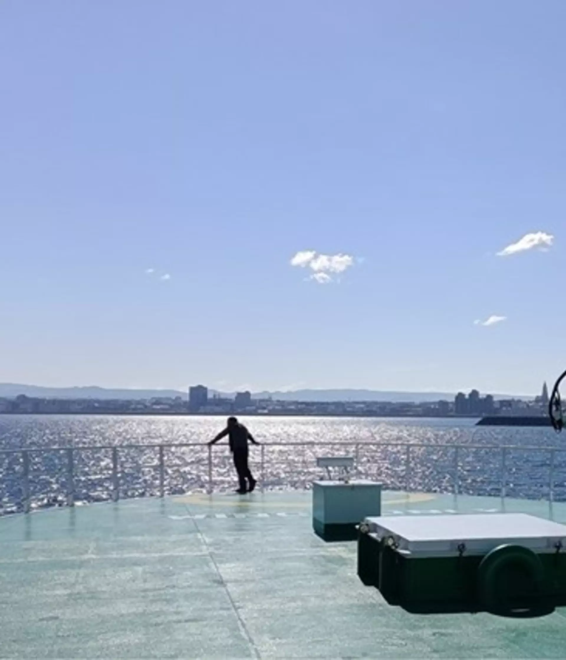
We were blessed with calm seas and fair weather for the entire duration of our expedition, including during a 24-hour transit from the north tip of Iceland to the south! Though a little chilly in the north, we were greeted by a rare sunny day for our return to Reykjavik!
After packing up the labs, all of our samples and cleaning everything, we had some time to reflect on some of the cruise highlights – and there were many (including a lot of cake!) so we have tried our best to summarise them for you here!
Preparing for the trip
We’re excited to be part of an international team of marine scientists about to embark on a 10-day expedition to explore the seabed of the Denmark strait, located between the east coast of Greenland and the west coast of Iceland.
Expedition BENCHMARK (Benthic Habitats in Denmark Strait) involves a multidisciplinary team of experts, including biologists and oceanographers from ZSL (UK), GINR (Greenland) and MFRI (Iceland). Onboard the RV G.O. Sars (our home for the duration of the trip), as part of a Eurofleets-funded research cruise, we will use a variety of ship-based techniques to map and image (photograph) the seabed and sample various aspects of the water column.
The Denmark Strait is a particularly interesting region due to its geological history and interactions between different water masses (creating the world’s largest underwater waterfall!) The seabed here is known to support a number of fragile, habitat forming marine organisms, but detailed distribution and composition of seabed habitats are poorly understood.
The term “Vulnerable Marine Ecosystem” describes seabed ecosystems often dominated by large, habitat forming sessile (fixed) organisms such as cold-water corals and sponges, which are sensitive to disturbance from human activities.
VME habitats are unlikely to recover from harm caused by bottom trawling, which is a fishing practice conducted along the continental shelf areas within the Denmark Strait. Additionally, very little is known about how deep seabed communities will respond to the accelerated effects of climate change such as those currently experienced in the Arctic and sub arctic region.

This expedition gives us the chance to create a baseline understanding of seabed habitats in this region, validate predictions of VMEs (that we’re expecting to be present there), and document the localised environmental gradients that may drive the distribution of these habitats (e.g. substrate type, slope as a proxy for currents/food availability, and seawater characteristics like temperature, salinity and dissolved oxygen). Characterising the seabed in this way is the first step towards effectively managing and protecting these vulnerable habitats. This research cruise will provide valuable information for fisheries operating in the region and contributes to our Marine Stewardship Council (MSC)-funded project working with Sustainable Fisheries Greenland to document VME habitats in Greenland.
ZSL’s decade of research along the western Greenland shelf has combined different imaging techniques including single images obtained from drop cameras and video from towed video cameras. These techniques give a unique snapshot of the biodiversity and distribution of seabed communities, but we never know what has been captured until the cameras are back onboard!
During our upcoming research cruise, we will be using a remotely operated vehicle (ROV) which flies along the seabed controlled by specialised pilots onboard the research ship. High-definition cameras on the ROV allow a continuous view of the seabed in real-time, meaning we can identify vulnerable marine organisms quickly, and accurately map the spatial extent of important seabed habitats (ie where and how large these habitats are). Additionally, the ROV houses a wealth of sensors that can characterise the oceanic environment at the seabed or selectively sample organisms that may be new or undescribed in this region.
Over the course of the expedition, we hope to give you some insight into the life of a scientist onboard a research vessel, and exclusive access to see some of the weird and wonderful sea creatures live from the seabed!
Svampa borg
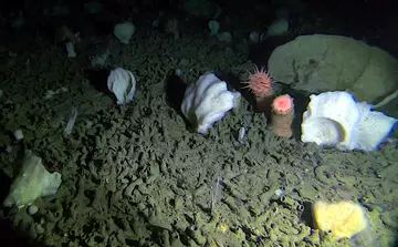
Towards the start of the expedition, we explored an area that was unbelievably diverse! So much so that you could not see an available spot that was unoccupied (by animals) for almost the entire time we were diving with the ROV (remote operated vehicle). Due to the diversity of sponges here I mentioned “This looks like sponge city” - 'sponge city' in Icelandic is 'Svampa borg' and it just stuck!
Stroking the sea pen
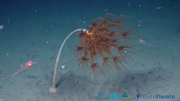
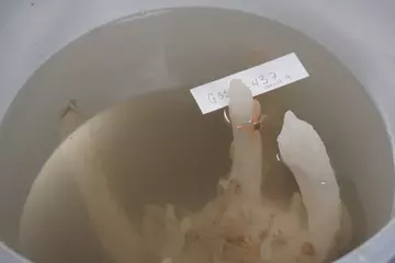
The sea pen Umbellula sp. has been reported to emit bioluminescent light from the stalk and plumes when agitated. We are not sure of the function of bioluminescence, however, we wanted to test if we could capture this natural behaviour. With the 4K camera on full zoom and all of the lights out, using the ROV’s robotic arm we gently stroked the stalk! Unfortunately, the camera was not sensitive enough to capture the light. We were able to bring a specimen to the surface and we tried rubbing the stalk again in a light locked lab cupboard and success! A faint glow of light was seen!
The weird stuff
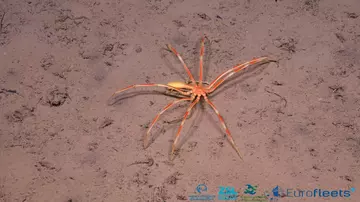
Sea spiders or pycnogonids are a pretty bizarre group of arthropods. They are predators or ectoparasites of soft bodied marine creatures. Though much work is to be done in understanding more about this interesting group, many use their long proboscis to suck up the tissue of their prey. The individual in this image was huge, and gave our ROV pilots nightmares for days…
Understanding relationships
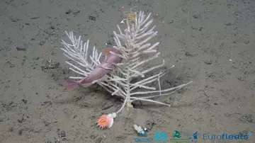
We don’t have many opportunities to make direct observations of how different marine animals interact with one-another in the deep sea. But we did have time to stop and observe some of these interactions, and this one (below) puzzled us.
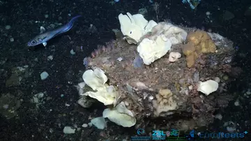
If you look closely, this branched carnivorous sponge is playing host to multiple invertebrates (small amphipods, seaspiders - one is brooding young, and a fish). This highlights the importance of structure forming animals which create habitats for others but also poses new questions – is this a carnivorous sponge? (It certainly looks like one in the family Cladorhizidae!) If so, why is it not consuming the smaller invertebrates?!
The 4K Camera
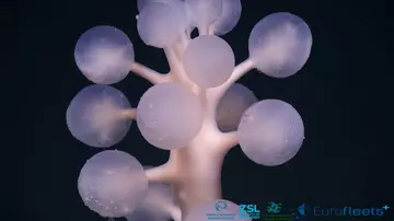
We are used to working with partial or dried specimens, so given the opportunity to capture the vibrance of these animals in their natural state was always going to be exciting. Yet our expectations were absolutely surpassed! The fine detail captured by the ROV’s 4K camera will help us ID animals much more easily, like this carnivorous sponge, Chondrocladia gigantea.
The team!
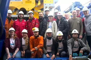
A wonderful set of ROV pilots, technicians and scientists made this cruise successful! Also, we are very thankful to the captain and the crew of the G.O. Sars for all their help and support.
So, what next? A little time off to get back to reality, and then the hard works begins where we start to work through the large amount of data collected!
Exploring starts with a map!
With the world’s oceans covering 71% of the Earth, it can be surprising to some to know that much of the deep seabed (greater than 200m depth) remains unexplored. Recent estimates suggest around 20% of the seafloor has been mapped to comparable resolutions using modern technology. Our current lack of knowledge here poses a number of issues for scientists working on predicting and monitoring our changing ocean.
At our current location in the Denmark strait, there are no high-resolution maps of the seabed. This means we need to use the ship and some specialised technology to map the area we wish to explore before deploying the remotely operated vehicle (ROV).
On land, we could use drones, planes, or even satellites to capture the changing topography, however, these techniques cannot penetrate deep water. Therefore, we use acoustics to “see” the seabed.
For our expedition, we use a multibeam echosounder, a type of sonar system that is fixed to the ship’s hull. The ship sails along multiple transects that cross the area of interest whilst the multibeam transmits many acoustic “pings” from a specific frequency, and receives them to an acoustic receiver when the sound bounces back from the seabed. This gives us information on the seabed depth, morphology (structure) and proxies that characterise the sediment characteristics (i.e. seabed hardness).
To help us map the complexity of the seabed in the Denmark Strait, geologist Davíð Þór Óðinsson joined us from MFRI Iceland. Davíð is responsible for planning and executing all seabed mapping activities during our expedition.
Davíð explained “The first objective with our mapping approach is to identify targets. The maps can show us what seabed features are there, and then we can pinpoint interesting targets that we will use the ROV to directly observe.”
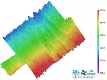
Above: A map of the dive site compiled from the ship’s multibeam; the colour is a gradient from deep (purple/blue) to shallow (yellow/red) depths. Each pixel in the image represents an area of 10m x 10m. The round dot is where we deployed the ROV, and we followed a transect (red line with direction arrows) across a feature called a fault scarp.
Across the site that would be the location of our last ROV dive of the expedition, the multibeam map highlighted some interesting seabed features that we decided to investigate. But before deploying the ROV, we decided to look at the backscatter of the multibeam (which is used to distinguish between different seabed types such as a rocky or a soft substrate) to get an idea of what we would expect to find, and then use the ROV to ground truth our predictions (check if they're correct!)
Davíð went on to say, “When we find interesting features, we can correlate these with backscatter to see if there are hard or soft patches in the substrate which may indicate a change in the seabed community.”
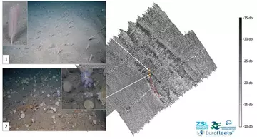
Above: Map of the backscatter across the dive site. There is a mixture of soft returns (light patches which indicate soft sediment) and hard returns (dark patches which indicate harder or rocky sediments) across the seabed feature. Image 1 shows a dense sea pen field, which was the most prominent community associated with soft sediment. Image 2 shows a mixed community dominated by sponges within the family Polymastiidae. This community was associated with a gravely sediment with drop stones. The yellow stars represent the location of each community image.
On deploying the ROV, we observed a very clear contrast between the seabed communities that occurred, which appeared to be associated with the changing hardness of the substrate.
Both the sea pens and a number of polymastiid sponges that were observed are classed as Vulnerable Marine Ecosystem indicator species so from a conservation perspective, it was truly wonderful to document such diverse and established seabed habitats!
You can watch the final ROV dive here which was streamed (without audio) to the EuroFleets Facebook page.
More than just water...
When you look at the sea it might look like a single blue mass, but it is actually a complex and dynamic mixture of waters with different properties. We can appreciate the complexity thanks to oceanographers like Andreas Macrander of the MFRI Iceland, who is using the cruise to get a closer look at the different water masses we see in the region. Andreas is here to measure properties of the water such as temperature, salinity and other aspects of ocean chemistry (such as carbon dioxide).
You might ask why a biologist should be interested in the water, but it is very important for marine animals that they live in the conditions to which they are adapted. For example most species cannot thrive (or even survive) in water that is too hot or too cold, so the oceanographic conditions can determine and limit where animals and communities live.
It pays to draw on the expertise of other researchers aboard. Last night we were deploying the ROV (Remote Operated Vehicle), but when it got down to around 900m depth (around 200m from the seabed) it suddenly shot off along a fast current.
The ROV pilots fought the current, but they could not safely move the system to the seabed and after a struggle they managed to bring it back to the surface and we had to abort the dive without seeing the seabed. The camera can operate in current speeds of up to 1.8 metres per second (about walking pace), so we know that the current must have been much faster than this, which is very fast for the deep-sea.
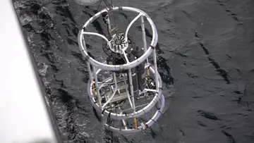
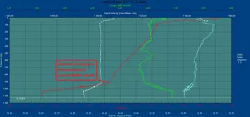
Fortunately, Andreas could shed more light onto the situation for us. He explained that there is cold Arctic water overflowing from the north, which creates a strong current, while the warmer Atlantic water sits over the top of this. We could visualise this on the temperature profile (see image below, showing how temperature (along the side on the x-axis) varies with depth (along the bottom on the y-axis)) as we can see a dramatic change in temperature as we drop below 900m. We conducted another CTD (CTD stands for conductivity, temperature, and depth, and refers to a package of electronic instruments that measure these properties) a few miles Northwest of this site, but saw the same profile, so we knew that this was still not a good place for the ROV. When the temperature profile changed, we could continue our camera sampling.
We've also been collecting water samples from close to the seabed, to measure the carbon dioxide and pH of the water. Ocean acidification isn't just affecting tropical coral reefs. We have seen substantial changes to pH levels in deep-waters around Iceland, which has been documented thanks to long term sampling and testing of the water by researchers at MFRI. The deep-sea corals we have seen are dependent upon extracting calcium carbonate from the water to make their skeletons (just like tropical reefs) and we are worried that, due to acidification caused by global CO2 emissions, some areas may soon be unable to support these beautiful habitats.
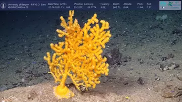
The science begins!
Our focus for this part of the expedition was an elevated seabed feature, much like an underwater mountain with a flat top. We arrived on station early with more time to dive than expected so, luckily, we were able to fit in a total of four Remote Operated Vehicle (ROV) dives across the area.
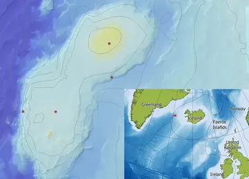
Seabed features that rise up from the seabed are usually associated with environmental conditions that support increased biodiversity, so we were excited to see what awaited our arrival!
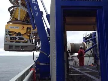
Descending through the water column we waited with apprehension, however the view that emerged from the darkness did not disappoint as the seabed was densely occupied with a variety of large sponges!
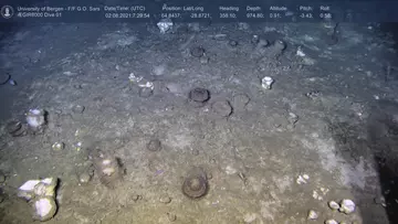
The community is much like a sponge habitat that is known as “Ostur” (meaning cheese in many Scandinavian languages – due to the appearance of many white sponges). This term was adopted from historical observations of sponge grounds by Faroese fishermen as a warning to others to avoid trawling the seabed as the sponges would fill their nets!
We were also surprised to see this seabed community was present across many of the areas we recorded, along with a small number of cold-water coral species. We were able to sample one of these corals, a “bamboo” coral of the genus Acanella.
In the deep sea, three-dimensional complexity is created by the presence of animals such as sponges and corals, compared to complex habitats on land, where structure is created by trees and plants. Habitat complexity is evident at this site, as the dense seabed community is creating a habitat that supports other marine animals such as sea stars, shrimp, octopus, fish, and sharks.
After each dive, we bring the ROV back up to the ship and remove all the samples. This is arguably (one of!) the best bits of an expedition for any deep-sea marine biologist as we get a chance to touch, smell, examine and identify a physical specimen in an almost perfect condition which is very rare.
The samples we take help us identify which species of sponges and corals are present at this location. From video alone, it is very difficult to identify them correctly. We will check the physical characteristics (morphology) of each specimen to try to ID them. We will also use DNA to check our initial IDs when we are back in on dry land.
However, our expedition is not done! Stay tuned for more updates as we steam on towards the rugged continental slope of Greenland!
All aboard!
“So much negativity is a positive thing!” Cruise leader Julian Burgos replied when I let him know the good news - Chris and I were covid negative from our final PCR test taken the day before boarding the RV G.O. Sars.
Much like the rest of the world, we have adapted our approach to conducting field work at sea to account for the risk of COVID-19. Though after a year and a half of home working, we deem these precautions essential, especially considering the time, financial commitment, and soul crushing disappointment that all the team would feel if the cruise could not proceed.
We officially left the old port of Iceland at 8am UTC on the 1st of August and we are headed towards our first sampling station 20 sailing hours southwest of Iceland. So far, we have been blessed with relatively calm conditions, the presence of seabirds and even a few whales on the horizon!
The work we will do at this station is particularly important as we aim to test our procedures and technology before transiting even further offshore. We will also be conducting acoustic mapping of the seabed and sampling of the water column using a CTD (Conductivity Temperature and Density instrument).
Though we are a team experienced with working at sea, we spent the afternoon taking safety drills with the vessel’s crew and getting to know the ship. Knowing where to muster and knowing how to don an immersion suit could save your life in the event of an emergency at sea!
We finally spent the afternoon discussing our final plans for sampling from the seabed. This is the first time many of us have met face to face or seen each other in a very long time, so we were very surprised to hear the dinner bell - time passed so quickly!
In the next update, we will have reached one of the most anticipated stations of the trip – an unexplored seamount which is much like an underwater mountain. This unexplored seabed feature is estimated to rise ~1000 m from the seabed.
Seamounts are known to be biodiversity hotspots and are usually home to many cold-water corals and sponges. We are very excited to see what we find!
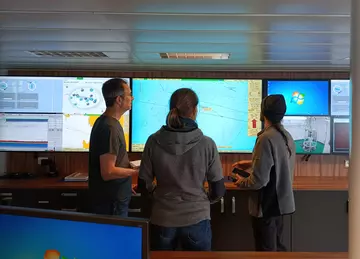
Meet the team
Emmeline Broad
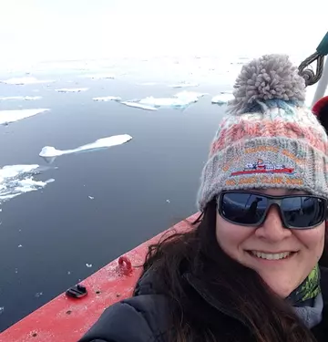
Emmeline Broad is an early career benthic ecologist with a particular interest in the conservation of polar and deep-sea seabed habitats. She graduated in 2020 with an MSci in Marine Biology from the University of Southampton where her dissertation focused on habitat mapping deep sea vulnerable marine ecosystems around western Greenland.
Emme says "I feel very privileged to continue my work in this incredible region as a research intern under the supervision of Dr Chris Yesson within the benthic ecology team at ZSL."
Emme's current research, funded by the Marine Stewardship Council, aims to evaluate the vulnerability of Greenland’s Arctic seabed habitats to the potential impacts of commercial trawling. Her work brings together several years of photographic and video surveys conducted by the team and their collaborators, and will shed light on the distribution, abundance, and diversity of vulnerable habitats in this vastly unexplored region.
Chris Yesson
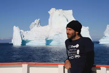
Chris Yesson wasn’t always a scientist. He studied Pure Maths and Russian Language at university and then worked as a management consultant. Then he decided to change jobs! After completing a biodiversity masters at the Natural History Museum and carrying out a PhD at Reading University investigating the evolution of plant groups, he joined ZSL as a marine biologist.
Chris says “I have always enjoyed the outdoors, and have been interested in conservation all my adult life. I really enjoy the opportunity to go to new places and discover new things. Looking at animals in the wild is exciting and I love the challenge of collecting data and analysing it.”
Chris’ work involves looking at marine habitats and trying to find out how human activities, such as fishing, are affecting these habitats. He spends time on research ships and takes photos and video of the sea-bed hundreds of meters below the surface. Chris has been studying the sea-beds in Greenland for the past ten years but still finds it exciting each time he goes there.
RV G.O Sars ship-time & ROV ÆGIR 6000 was provided free of charge for the BENCHMARK expedition, as part of the Eurofleets+ project, which is funded by the European Union’s H2020 Research & Innovation Programme under grant agreement No. 824077.
Chris and Emmeline's research is supported by the Ocean Stewardship Fund (OSF) program of the Marine Stewardship Council.
